
Reading’s history is filled with stories and questions that lead to more questions. It is easy to get pulled in, and all else is put aside while trying to satisfy one’s curiosity. Recently, when researching information about Reading’s first (and second) post office, I came across a section in Eaton’s History of Reading (1874) entitled “Tornadoes”. The paragraph on page 544 was particularly intriguing. It recounted a tornado that occurred on Thursday, August 13, 1857. It mentioned several homes and properties that were damaged – prostrated orchards, a schoolhouse turned on its foundation, barns razed, and so on. But the descriptions were given by the names of the property owners at the time. Would it be possible to determine the path of that storm? Reading’s 1854 map was a good place to start.
But there are other sources: the Polls and Estates from 1850 and 1860; the Massachusetts State Census from 1855; the Map of Middlesex County (1856); Reading’s Colonial Rooftrees; and Reading’s Historical and Architectural Inventory. All proved helpful.
So let’s start. The tornado was accompanied by a thundershower and took place about 7 or 8 o’clock in the evening. It is said to have started at E. Appleton’s. In 1854, Edward Appleton lived in the house at 201 Woburn Street opposite the end of Pratt Street. According to Eaton, the tornado “thence took a southward course, prostrating a few apple trees and fences on the land of Thomas Sweetser.” At first glance, that would seem to be a little curious. Most people familiar with Reading history, connect Thomas to Parker Tavern and a house on Main Street – not really south of Appleton’s. In 1850 Sweetser owned a house and over 52 acres of land. But the locations are not detailed. By 1860, he owned four houses: one on Main Street at the current location of the car wash (374 Main) which remained the family homestead for several generations; Parker Tavern (103 Washington); one on Union St; and one on West Street. And he owned over 87 acres, including 9¾ acres with Parker Tavern.
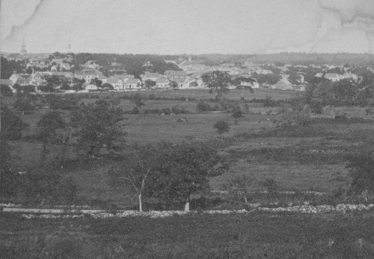
This photograph was taken in 1871 looking east from Scotland Hill and shows that much of the land from Summer Avenue (in the foreground) to the downtown was open land. So where those trees and fences were located is virtually impossible to determine.
But many of the other references to the tornado’s path are easier to track. The article says that the Prescott Farm lost many trees. The farm at that time included 81 acres of land on both sides of Summer Avenue. The house’s current address is 284 Summer Avenue. The house of George C. Coney received “considerable damage by falling branches from the Elm out front”. George’s house was located on the east side of Summer Avenue, was torn down in 1954, and is the current location of Rachel Road. Next, we come to the property of Deacon Thomas H. Sweetser (not the Thomas Sweetser who owned Parker Tavern) where “the orchard … was almost entirely prostrated, and the building occupied by him as a shoe factory completely wrecked.” Deacon Sweetser’s house and shoe shop were located on the east side of what is now known as Leach Park, formed by the intersection of Summer, Walnut, and Hopkins.
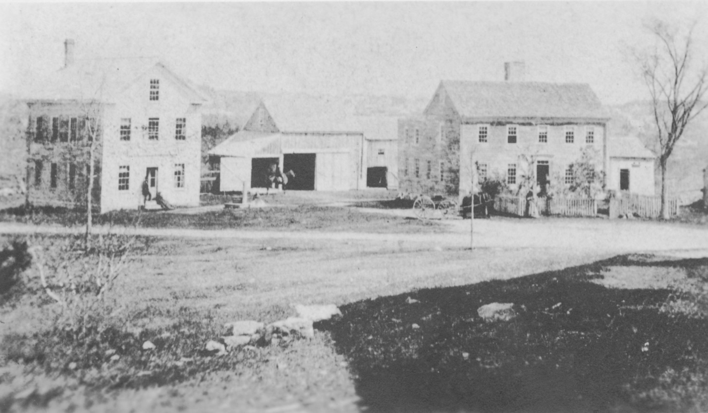
This early photograph shows his house, on the right, and other buildings, including his shoe shop on the left. The house was moved about 1871 to the current location of the Joshua Eaton School and was torn down in 1949 for the school’s construction. The shoe shop was also moved in 1871 to the southeast corner of Green and Ash Streets (104 Ash). There was little photography before the Civil War, so is the shoe shop shown in the photograph a rebuild after the 1857 tornado? The tornado’s next victim was “the schoolhouse upon the hill” which was “turned upon its foundation about six feet”. That schoolhouse, built-in 1854, was known as the Walnut Street School and was located on Leach Park and created a large shadow across the street from Sweetser’s house in the photograph. According to Eaton, the house of A. F. Converse “was similarly displaced”. His house was located on Hopkins Street, on the west side of Leach Park.
The next group of properties mentioned was all located relatively close to each other. “D. F. Weston’s buildings were considerably injured.” That property was located on the east side of Main Street at the corner of Hopkins Street. Also, the home “previously owned by John Weston, Esq.,” Leaning Elm Farm, located just to the south “was partially destroyed, and Mrs. Austin who resided there was completely shut in by the ruins.” And the most colorful story of all was that the barn of John Parker, located on South Street just west of the intersection with Main Street, was razed and “a horse in it was carried over two walls and the street, before being found uninjured and quietly feeding.”
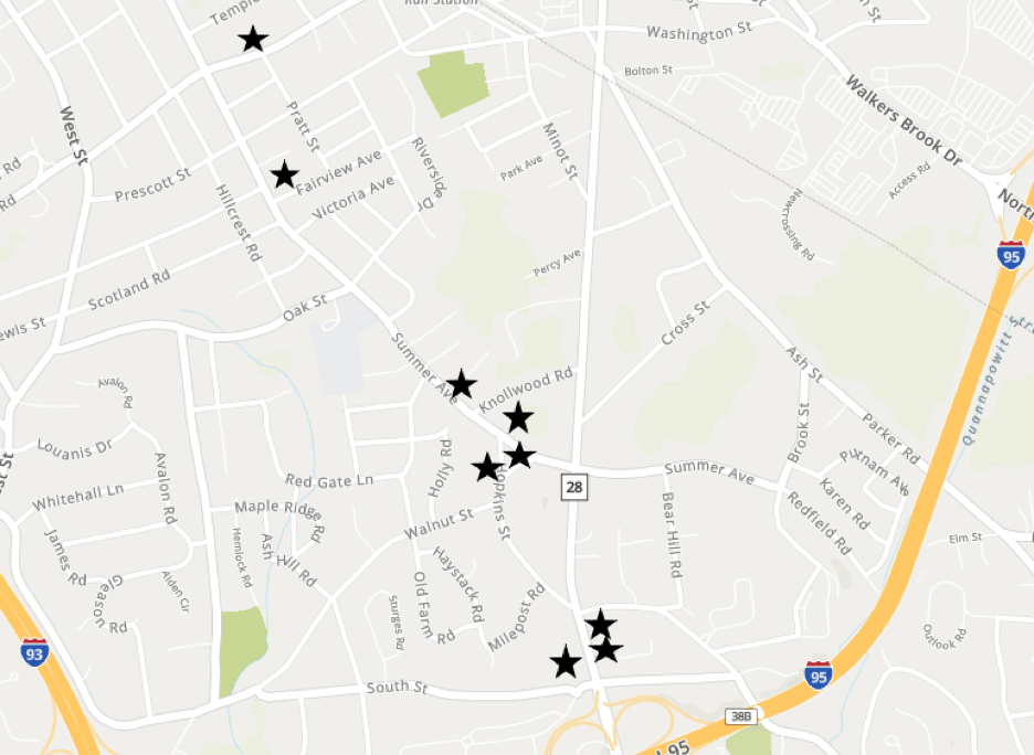
The map below is marked with the locations that were able to be determined.
And we can certainly presume that the tornado did not stop at Reading’s southern boundary. I wonder what damage, if any, was done in Stoneham or Wakefield? But that is for some other researcher to pursue.
Ginny and her husband, Everett, wrote Images of America: Reading which is still available by contacting the authors at evblodgett@comcast.net. Proceeds from the sale are being donated to support the Reading Antiquarian Society – Parker Tavern.